JWA leverages 10+ years of experience working with transit agencies developing beautiful reports and planning-level network maps to provide custom wayfinding and network discovery products. We believe that while smartphones and trip planning applications have reshaped how riders use the network, an agency’s own clear maps and schedules remain an essential tool for helping people discover the range of possibilities transit can provide. Static network maps, in contrast to interactive maps, are able to show an entire network on one page, giving passengers a starting point from which they can seek out more detailed travel information Our products help draw attention to the attributes of transit service that people time and time again rate most important – frequency, span, and connections.
Our map design team has developed a variety of products for transit agencies big and small, including full network maps, individual route maps, route brochures and timetables, and passenger guides.
Where have we worked?
AC Transit (San Francisco Bay Area), Monterey-Salinas Transit (California), Miami-Dade Transit (Florida), and Akron METRO (Ohio) are among the agencies that are currently using JWA-designed maps as their primary public-facing maps. JWA has made both network maps and route brochures for Valley Regional Transit (Boise, Idaho), and Suffolk County Transit (New York). JWA led a full redesign of all products for Suffolk County Transit, including development of a passenger guide and support for a new website.
Miami-Dade Transit
Monterey-Salinas Transit
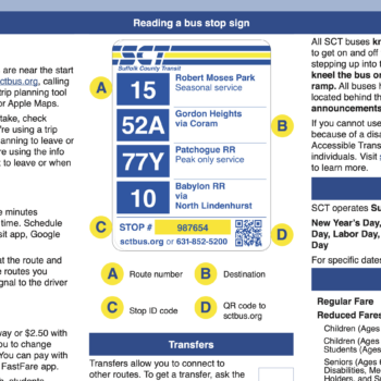
Suffolk County Transit Ride Guide

Akron METRO
Suffolk County Transit
Valley Regional Transit
How do we do it?
Our overarching goal with any project is to create tools for network discovery – that is, helping people understand where and when they can go on transit. Each project starts with a kick-off and high-level visioning exercise to understand the goals for a new network map and any preferences or agency guidelines for the design. We strive to produce a final product that makes the network clear and easy to understand for passengers, and offers a helpful tool for a range of communication efforts.
Over the course of the project, we meet regularly to show progress and to get feedback on the work as it happens. Our experienced cartographers and graphic designers build their files with structures and systems to maximize the efficiency of long-term product continuity so our clients have maps, brochures, and guides that they can feel confident about maintaining for years to come.
At the end of the project, we always provide our clients with the original art files and guidance for updates, in addition to the completed products.